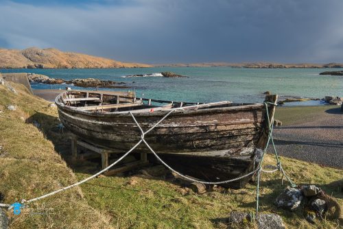
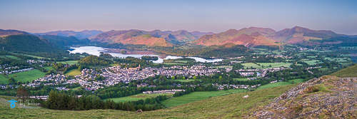
Good day everyone and welcome to my latest blog recording my recent visit to Elterwater .
June has been a quiet month for me photography wise, until I looked at the weather apps, we were heading for a morning of pre, and post sunrise mist followed by some sunshine, ideal conditions I thought.
The alarm goes off at 2.45am, ridiculously early I know, but needs must and as a Cumbria photographer I needed to get to the south of the county.
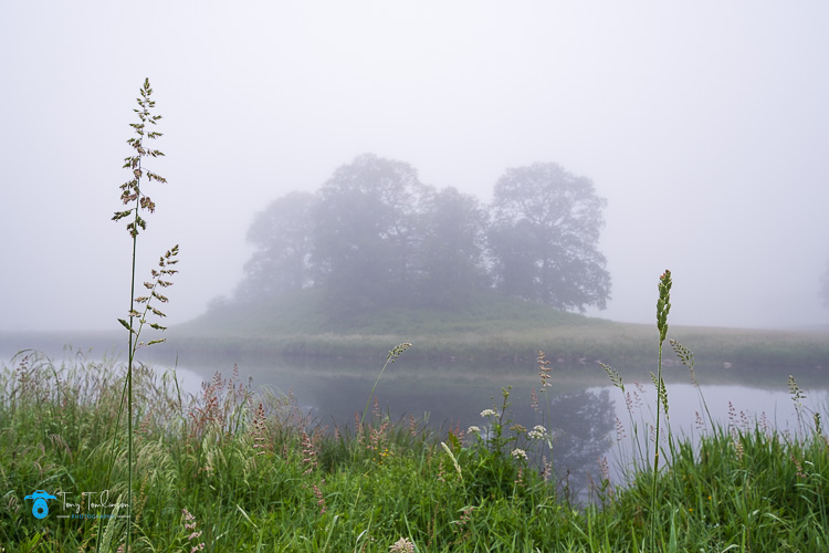
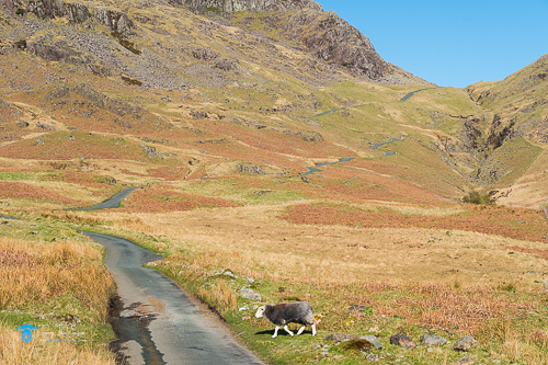
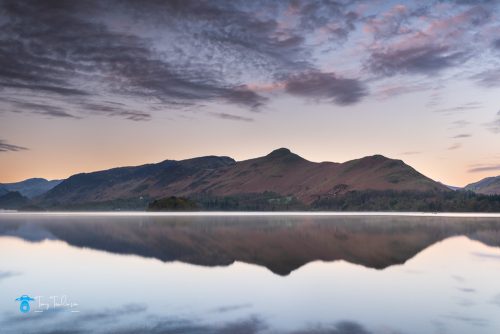
River Brathay
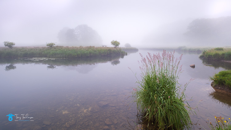
I arrived at the River Brathay 45 minutes before sunrise, this being one of the best photography locations in the Lake District for misty conditions.
I had plenty of time to settle in and secure a good spot, the mist was present, but it was peasouper, the mist was so dense with little or no chance of it being burnt in time for sunrise.
As there was little or no chance of the sun making an appearance, I set to work with the conditions.
The fist photos were taken from the bank of the River Brathay looking back towards Elterwater, I found some coloured grass seeds that contrasted to the bleak, almost monochrome conditions, and balanced this with three small bushes on the opposite bank of the river.
Summer Seeds
I then slowly made my way along the riverbank trying to find some reasonable photos, this ended up me looking for some small detail within the frame in the hope that it would add some interest.
In this shot I simply used two tall grass seeds to flank the wooded cops on the opposite side of the river.
Flanked by Seeds
I was struggling, the mist showed no sigh of lifting and time was pressing, it was now 15 minutes after sunrise, and we were still swamped in thick, dull mist., the joys of being a Cumbria landscape photographer
I bumped into a fellow photographer on the edge of Elterwater who was visiting from Nottingham, we had a long conversation about all thing’s lake district and photography.
It was here that I found a brightly coloured Pepper Pig shoe that had been placed in the “y” joint of a tree, I couldn’t resist the shot, a photo that was made to manipulate in post editing, what do you think of this, would you prefer the photo below, it being all colour, or it being all black and white, please feel free to leave a comment.
The Shoe
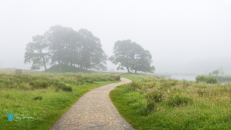
As my time was running out, I began to track back to the car, where I snapped a shot of the winding footpath leading in to the abyss, with some trees shrouded in mist.
The Path
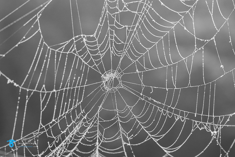
I walked back through the meadows and found loads and loads of spiders webs, coated in droplets of moisture and silhouetted against the dark background, another snap and grab scenario.
The Web
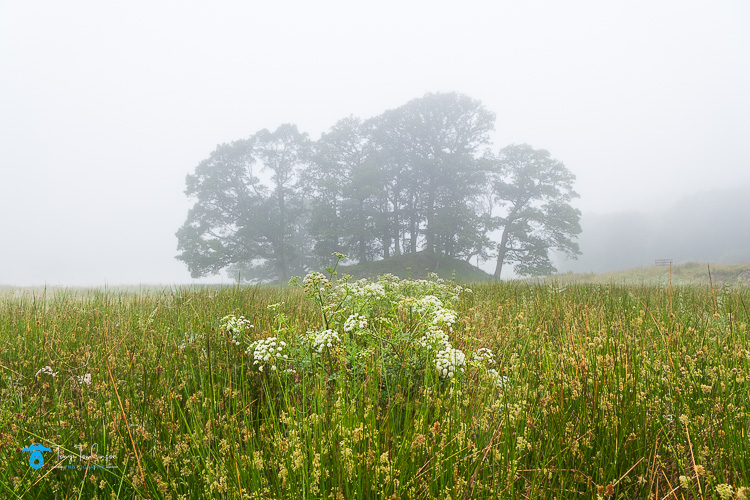
Immediately after this I took my last shot of the morning using the meadow foliage as foreground against the tree shrouded in mist.
Tree in the Meadow
Another Lake District Sunrise photography shoot done, not as planned, but worthwhile in getting me out and about again.
Thank you for finding the time to read this short blog, until next time stay safe.
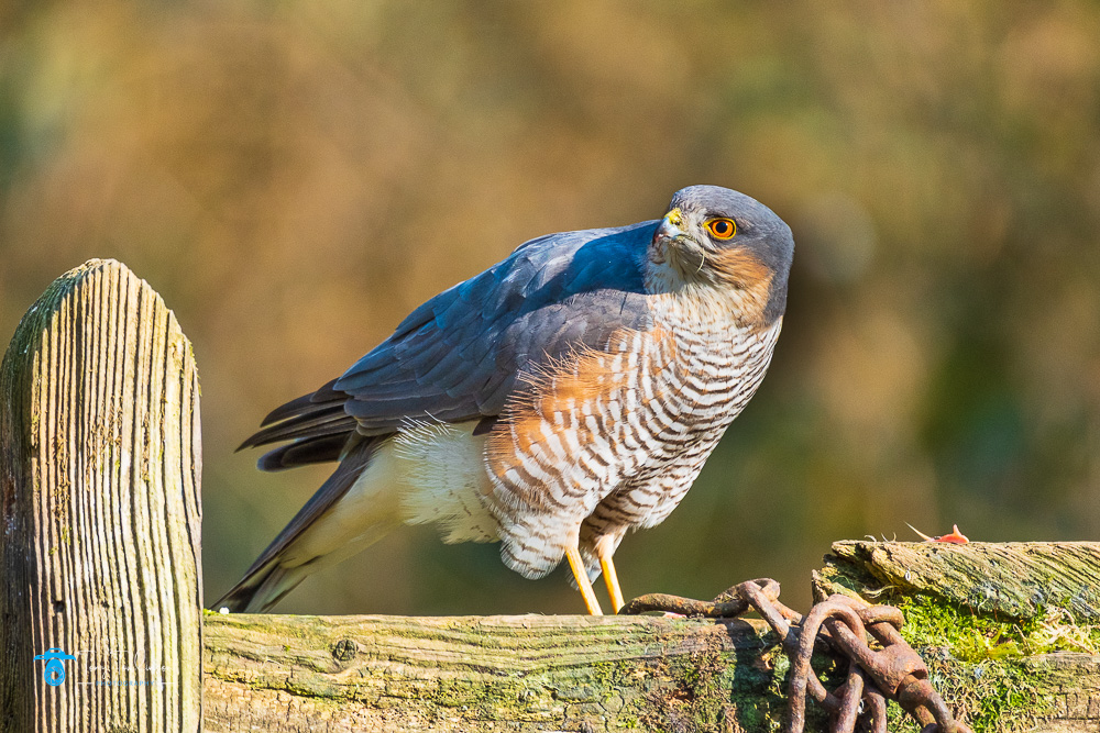
As a Lake District photographer, and a Cumbria Landscape photographer, I also participate in a little bird and wildlife photography, not as a speciality, but more of a hobbyist, a bit of fun and enjoyment.
Cumbria Woodland Photography Hide
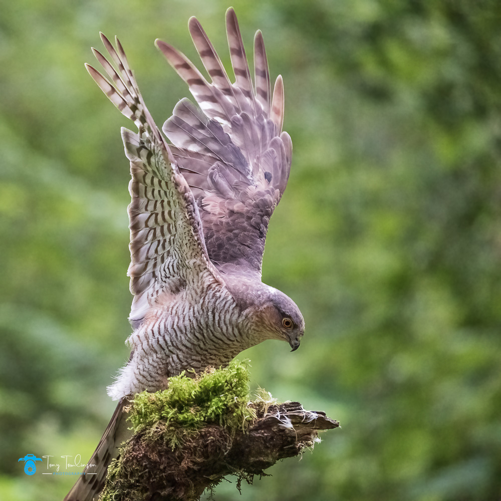
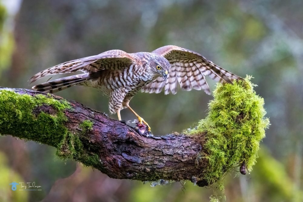
My first experience of Bird Photography was at the Cumbria Woodland Photography Hide, which I have been frequenting for over 4 years now.
Stephen and Linda have worked their socks off in creating and developing the hide, which now regularly attracts sparrowhawks, Jays, and a whole host of small woodland birdlife.
I began photographing birds using my 70-300mm telephoto lens but soon realised that this did not have sufficient reach to get close-up images of the birds. After a bit of saving up, I then bought a 100-400 lens which helped and was further improved when I added a 1.4 tele converter to the lens.
When I purchased my APS-C camera, I even managed to get hold of a very reasonably priced 500mm f4 lens, this was a beast, very large and heavy, and to be truthful to long to capture the birds at the hide, hence its trade-in when I changed to a full frame Canon system, but boy did it produce great quality images.
My technique of shooting birds gradually improved, as I began to “read” the small birds (these are very fast-moving creatures) to be able to capture them in flight.
Looking back at my early photos of the birds, these were nothing special, but everyone must start somewhere.
Female SparrowhawkBlue Tit and Great Tit
My technique has improved as my visits to the hide increased, and as the hide was improved over the weeks, months, and years.
As the hide developed, many more people have begun to use it, Stephen and Linda have secured an almost guaranteed visit from the Sparrowhawks.
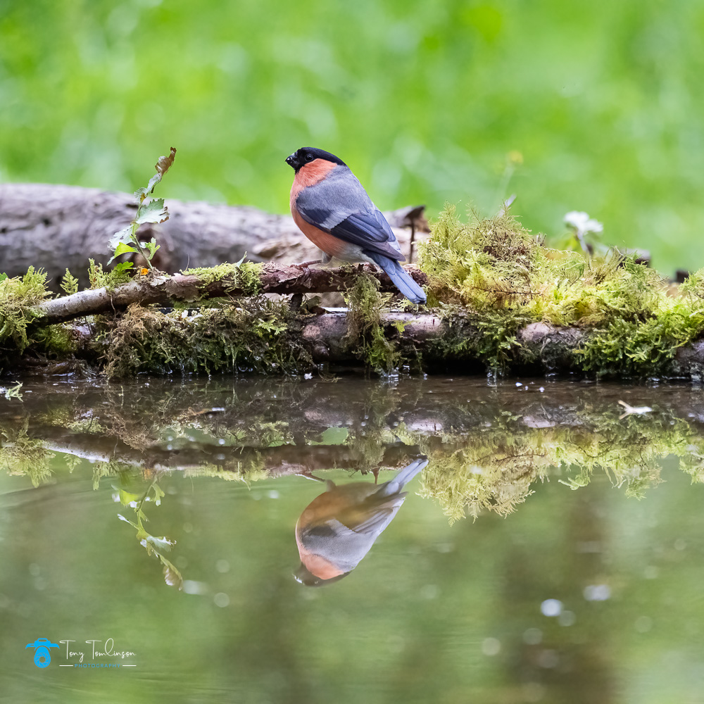
Male SparrowhawkBullfinch Reflection
From visiting the Cumbria Woodland Photographic Hide, I began looking for more opportunities of photographing birds in differing locations and conditions.
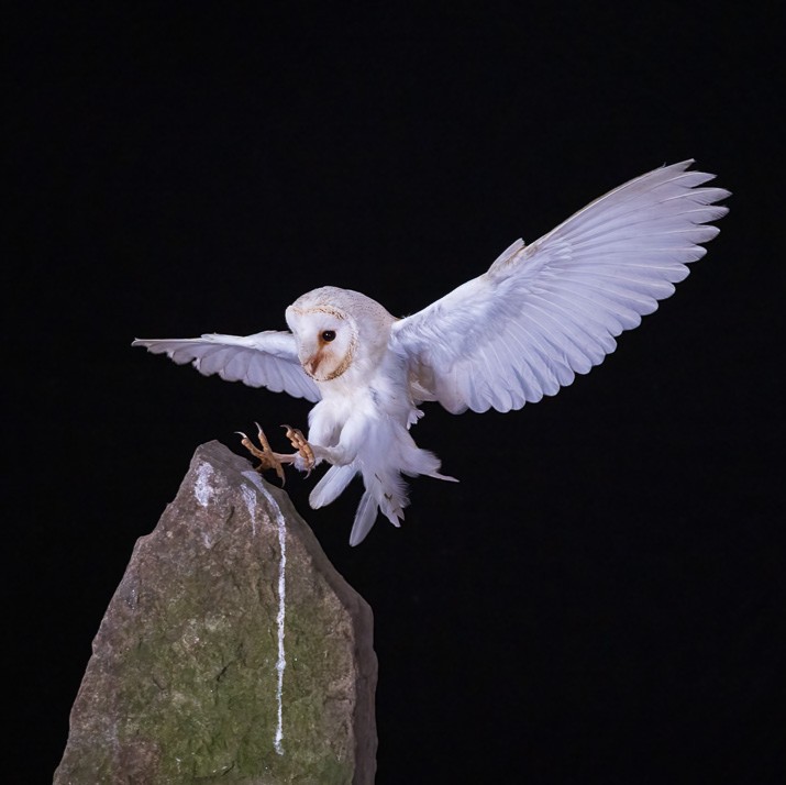
Northwest Wildlife Workshop
My first chance to visit another location was on a Northwest Wildlife Workshop based at Ashton in Lancashire.
This workshop had been recommended to me by another photographer, so one bleak autumn morning, I set off travelling to Ashton.
The morning was very enjoyable, we were based in a huge field, the birds were tethered but placed on perches in realistic locations from where we could photograph them.
A good variety of birds were used, and a vast amount of information about the bird’s habitats being provided by the people who were running the workshop, not just a shoot and leave event, you learn a little as well.
I thoroughly enjoyed the experience of the workshop, from which I captured some great photographs.
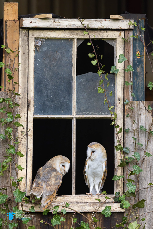
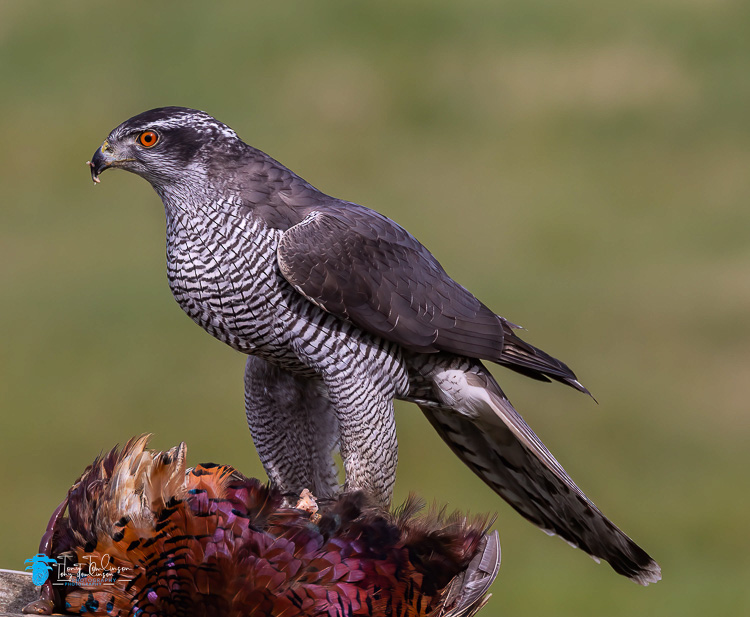
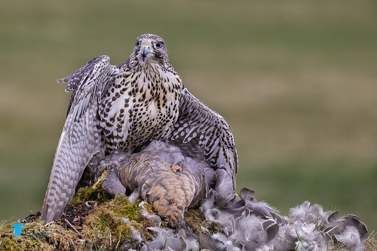
Barn OwlsGyrfalconGoose Hawk
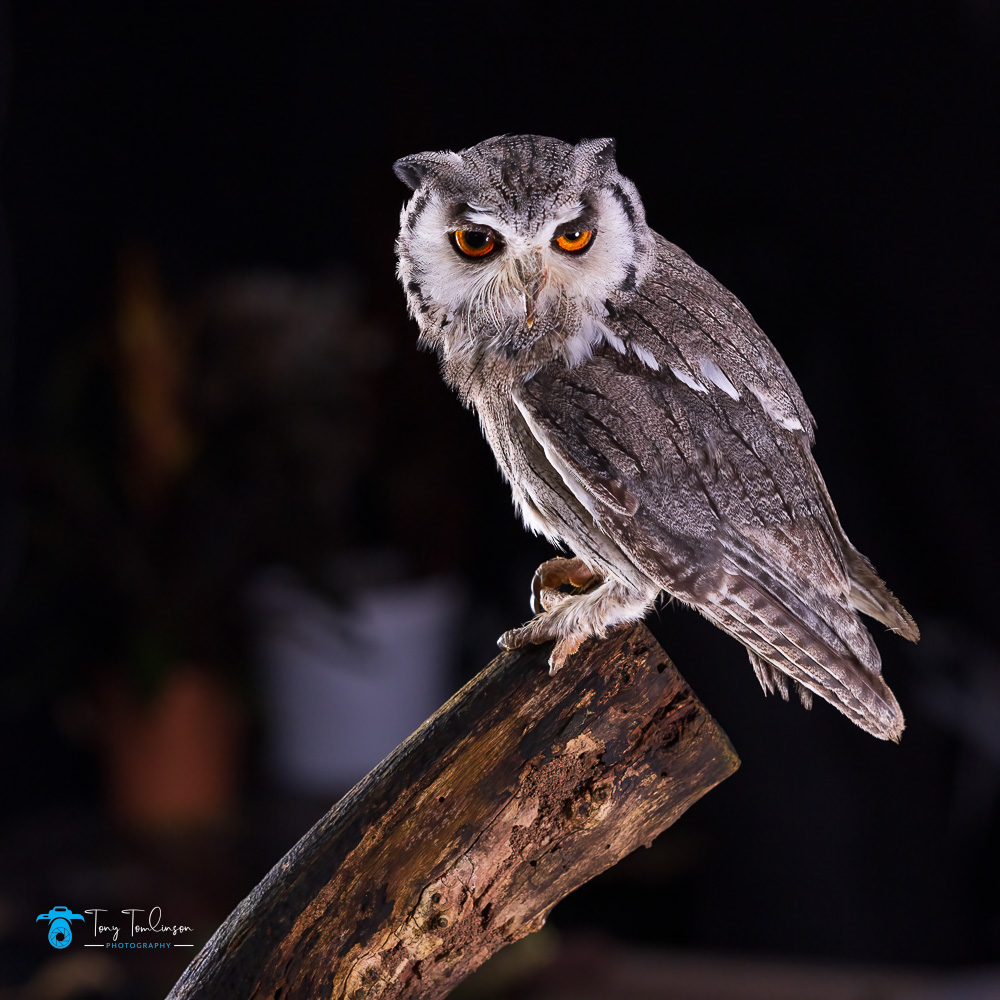
Andy Howey’s Photography Workshops
I have also attended one of Andy Howey’s Photography Workshops, which are held in the Northeast of England. again, on the recommendation of a fellow photographer, this was a very enjoyable small indoor event where a selection of birds was photographed, perched, and inflight using LED lighting set-ups.
I found Andy’s workshop fascinating, working within a confined space, Andy showed great care of the birds, and created lighting which produced excellent photographs. His knowledge about each type of bird was impressive.
Southern White Faced Owl
Barn Owl
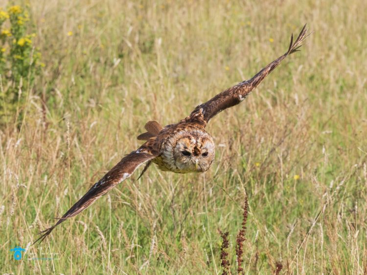
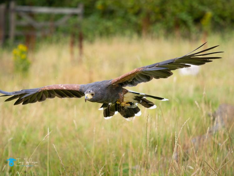
Gauntlet Birds of Prey Photography Workshop
Another workshop which I attended was at the Gauntlet Birds of Prey Photography Workshop at Knutsford in Lancashire.
This was hosted by the renowned wildlife photographer Gary Jones Wildlife Photography, a 6-hour workshop where a wide selection of birds of prey is allowed to fly for you to photograph in natural outdoor locations. An element of education is also provided throughout the day by members of staff, and a small lunch is provided on the day of the workshop.
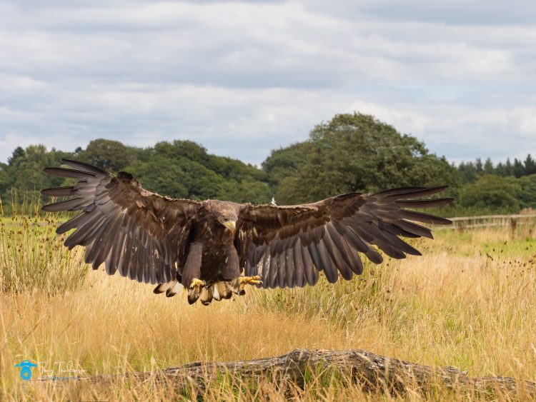
Birds which were photographed on the day included (but not restricted too) Common Buzzard, White-Tailed Sea Eagle, Steppe Eagle, Tawney Owl, Long Eared Owl, Harris Hawk, amongst others.
Another fully enjoyable days photography, well worth the 6-hour return journey.
Tawny OwlHarris HawkWhite Tailed Sea Eagle
Scotland
We visit the Highlands and Islands of Scotland on a regular basis, were, you would think we would see a wide selection of wildlife. I have on occasions seen or come across Red Dear, but I have failed to see any of the renowned birdlife in the Highlands, probably due to my very poor eyesight.
The one time when I though we would see plenty of wildlife was the one time that we have visited the Isle of Mull, an Island that is renown for its wildlife and bird species, sadly, on our visit, I failed to photograph any animals of birds.
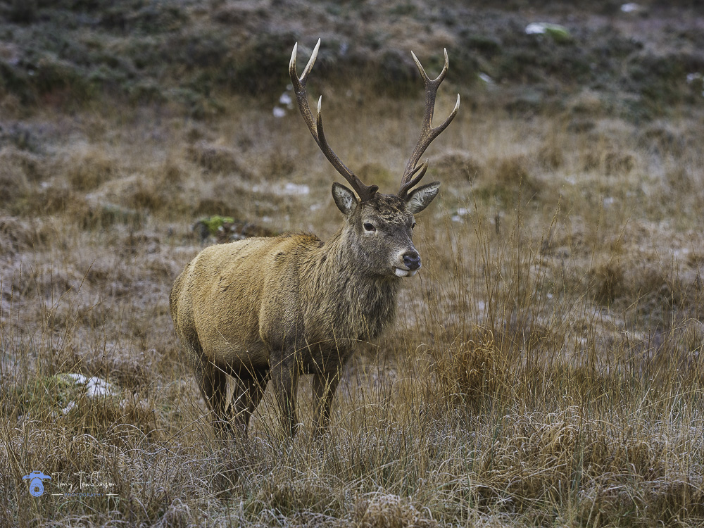
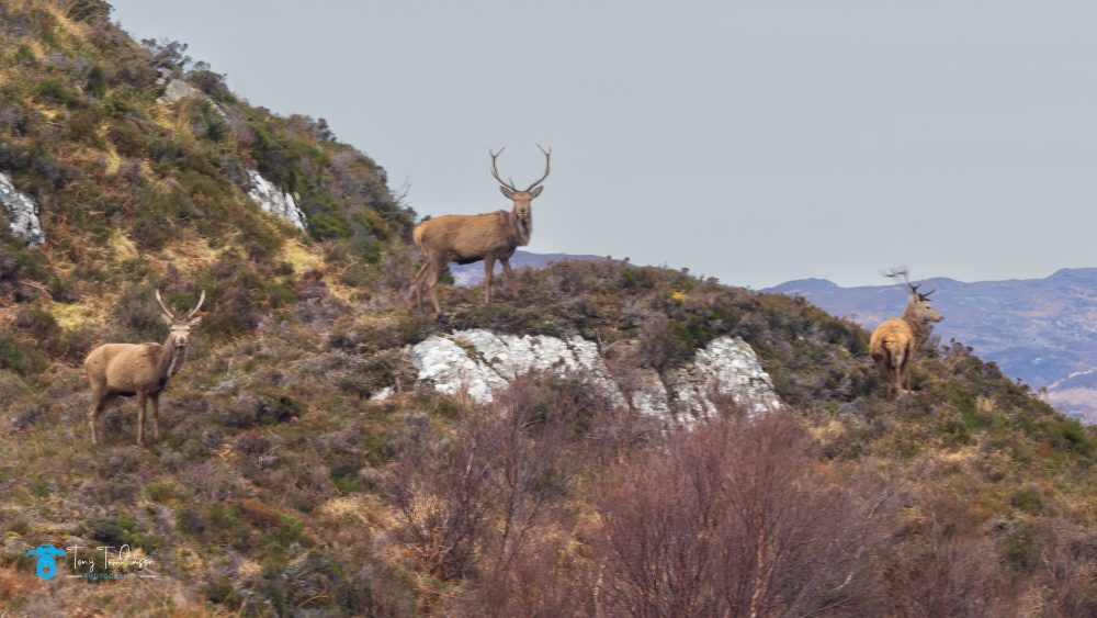
I have had slightly better luck in shooting red deer in Scotland, these majestic animals do take some finding in the barren landscape as their coats are ideal camouflage against the brown winter bracken.
Red DeerRed Deer in Assynt
Lake District
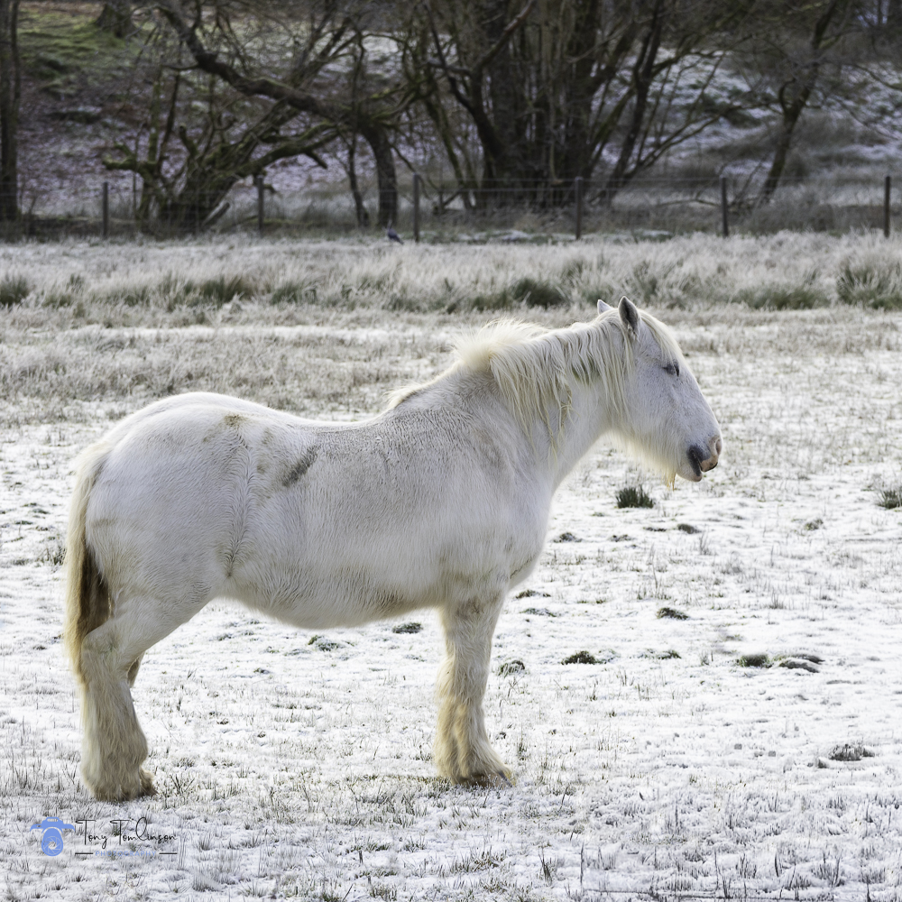
On my travels within the Lake District, I often come across a wide selection of animals, sheep, cows, horses, etc, and whilst I may ignore these on many occasions, every now and then a scene will include an animal which I wanted to shoot.
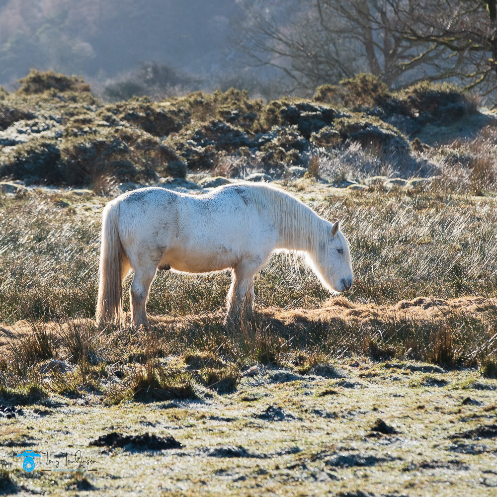
An example of this is that on the winters morning of me walking around the shores of Crummock Water, I stumbled across a couple of white horses that were back-light against the early morning sun, this scene created a very nice photograph.
Crummock White Horse
Another time whist in Glencoe, Scotland and whilst driving along the route of the River Coe looking for compositions, I came across another white horse, calmly eating its morning feed, with its coat blending into the white frost covered field.
Glencoe White Horse
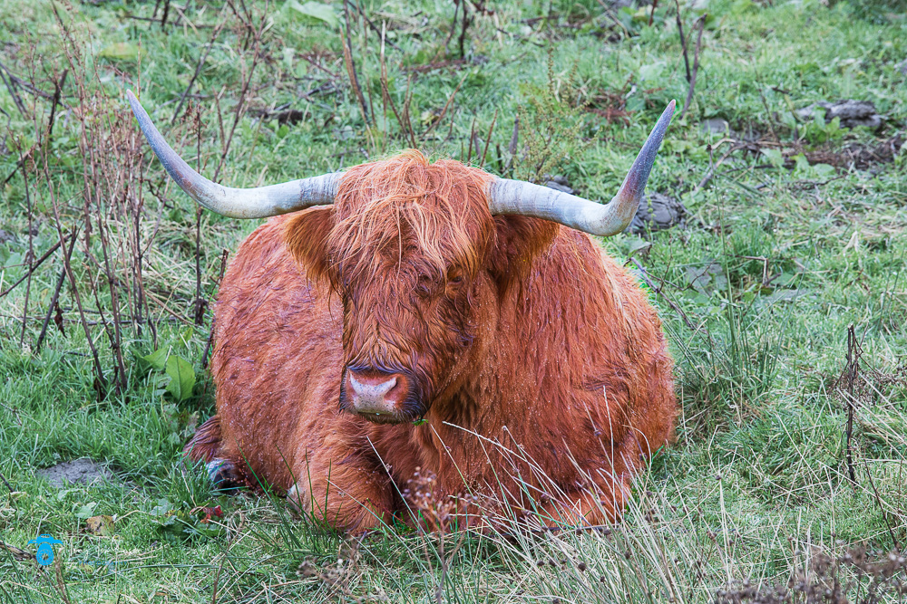
One animal you do see plenty of in Scotland is the Highland Coows, these magnificent beasts provide an image that is soly related to Scotland, whatever the weather these beasts always make an interesting photograph.
A Highland Cow
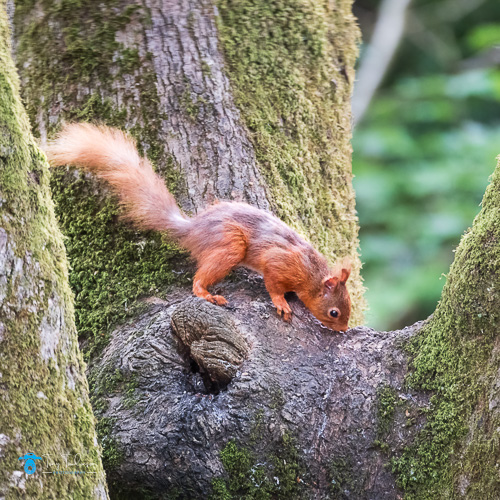
Red Squirrels
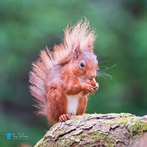
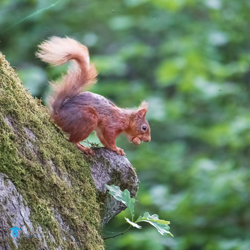
An animal that I have wanted to photograph for a long time is the Red Squirrel, not knowing where to find these has always been a bone of contention, but several months ago, a good friend Lorraine agreed to take me to a local location where she had been photographing these intriguing creatures.
On the first visit, I took everything in, just so I would not be doing anything wrong if I returned on my own and captured several nice images to boot.
Several days later we were back, and this time the Squirrels were on form, I got some very good photographs of them running up and down the trees and jumping along to floor.
This has been the start of new chapter in my photography, I have returned several times to try and photograph them, sometimes they turn up, sometimes you never see on, but that is part of the challenge.
A Red Squirrel feedingA Red Squirrel tree hopping
My family photography in Cumbria and selling my Lake District photography prints could not be further from the subject of photographing birds and wildlife, but for me, this is the enjoyment of photography, not to be totally indulgent in one subject, the variety keeps creating the interest.
Granted I do specialise in landscape and portraiture, but bird and wildlife photography bring their own, and unique challenges which I fully buy into.
Thank you for reading this article, until the next one by for now.
The month of May was split into two defined timescales, the first two weeks produced only one photography activity, whilst the last two weeks of the month produced a flurry of activity.
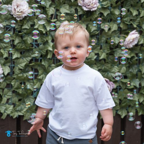
Garden Photo Shoot
The month began with a ad hoc photo session with Cody, a short and fun session in the garden with a bubbles machine, the plan was to set off the bubbles and try and capture Cody’s facial expressions.
Bubbles and Cody
The next photo activity for me was on the 23rd May when we visited Northumberland, we enjoy visiting the Commissioners Quay Inn, having stayed here several times and enjoyed our stay each time.
Blyth
The weather during our stay was exceptional, clear sunny days for each of the four days, the plan was to enjoy the area and secure some quality R & R.
The first day was a slight lie-in, enjoy the breakfast then take a leisurely walk along the beach and in the park, where coffee and cake was the order of the day.
The second day began with a gorgeous 5.05 am sunrise, I only seen it due to me waking unexpectedly, on the back of this, I decided to get up and photograph the sunrise for the following day, the forecast was much the same, so a 4.30 am alarm was set.
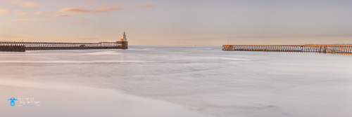
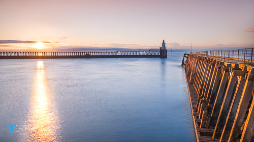
My plan was to visit the two jetties at the entrance to Blyth Harbour, the reasoning being that it was not too far away, and I thought that I could get some decent images from this location.
I was surprised how warm it was at 4.45am, my coat was swiftly discarded, with a tee-shit being the order of the morning.
I began the long(ish) walk along the southern pier with the aim of getting to the end of it which would create a suitable angle looking towards the lighthouse in front of the impending sunrise, unfortunately, this was not possible as part of the wooden pier had collapsed and was fenced off.
A quick improvise to lign-up a shot, then back to the beach to capture some shots whilst the sun was still relatively low in the sky.
Blyth Harbour EntranceBlyth Lighthouse from the Southern Pier
A satisfying mornings photography, and back to the hotel in plenty of time for the cooked breakfast.
This being the only photography of this trip, as I said it was aimed at plenty of relax and recreation.
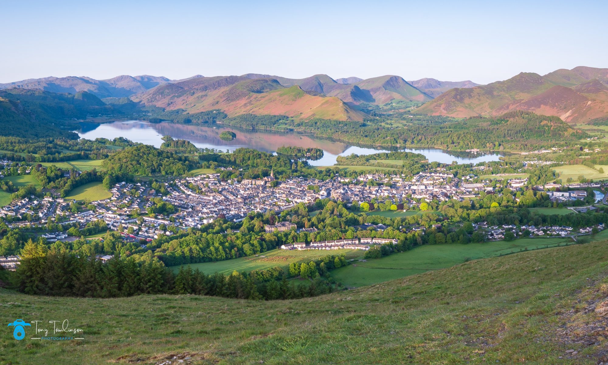
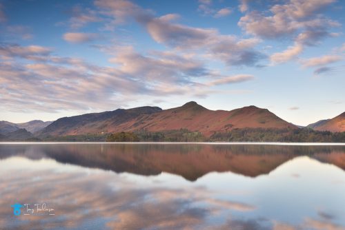
Latrigg Fell
Once we were back home, and only a couple of days later, the weather gods were being kind, so it was another ridiculous alarm call to get me on top of Latrigg Fell well before sunrise.
The plan was to capture some pre-dawn blue-hour images, then concentrate on a shot that would go into my website portfolio section.
Overall, a nice morning’s photography with a suitable set of images, not the most original, but nice light conditions, and a sharp set of images.
The View from Latrigg
I was back home before 8.30am with a well-deserved sausage sandwich purchased from Cottage Pie at Dearham on the way home.
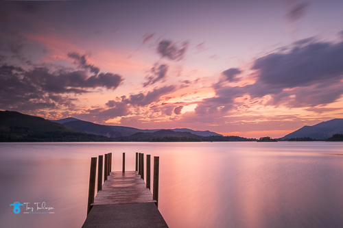
Ashness Jetty.
The very next afternoon I was off to Ashness Jetty with the aim of securing a decent sunset image of the newly constructed pier which replaced the previous version which was wrecked during the winter floods.
Surprise number one was that I was unable to park in the car park on the road up to Ashness Bridge, this being full of cars, and a burnt-out wreck of a car, I managed to park the car just above the road junction.
Surprise number two was the number of people on, and around the jetty swimming in the Lake, it’s a while since I have seen this many people swimming in the water, but nice to see.
All I could do was wait and be patient, in the hope that by the time the sun began to set, the swimmers would have dispersed.
Waiting was not enjoyable, all I could do was picture compositions in my head, and wait for the people to leave, slowly, very slowly the number of people began to reduce, eventually leaving two paddle boarders, and a couple of people swimming, but I could work around these.
I needed to set the camera on the tripod so that I could capture a range of exposures which could be blended in post processing, this was necessary due to the very high dynamic range of the scene.
I was soon on my own, with a set of decent photographs, and a hope that one set of exposure brackets would be good enough to make it into my website portfolio.
Ashness Jetty Sunset
Harrington Railway Line
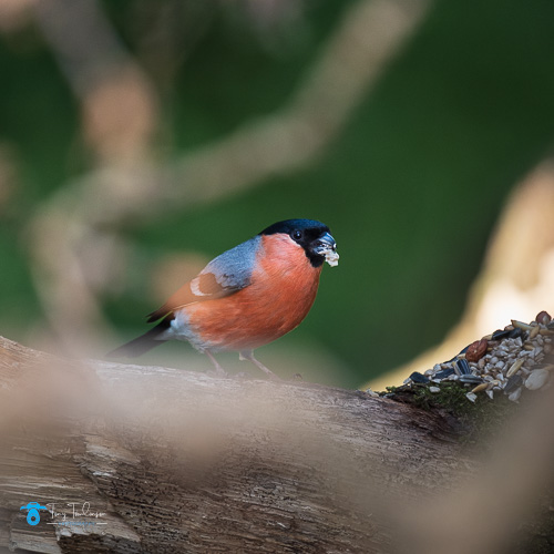
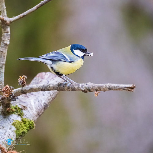
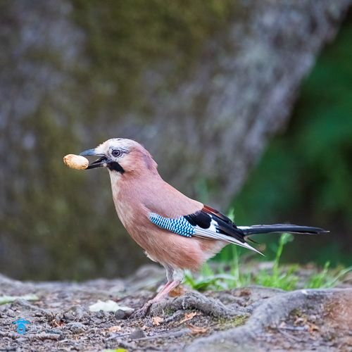
It is some months since I was last out to photograph the Red Squirrels at a local location, so I had a plan to visit here to try and get some more images of these lovely animals.
The temperature at this time were very un-seasonal in the mid to high 20’s, which I was unsure if they would affect the Squirrels.
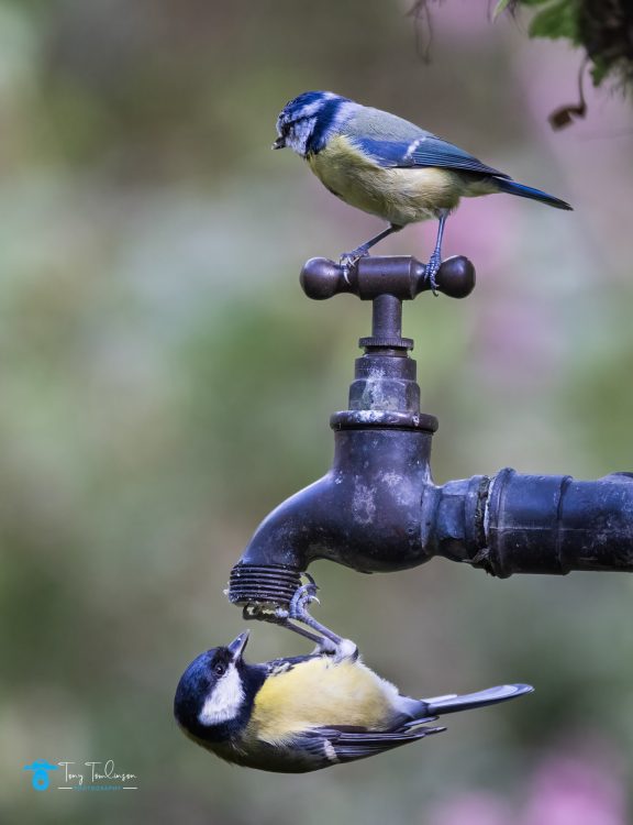
Visit one, during the afternoon drew a blank with the Squirrels, I shot a few birds but that was it.
BullfinchGreat Tit
Visit two was a early evening visit, again no Squirrels on show, and it was soon too dark to take any reasonable photographs, so it was home empty handed.
Visit three was the nest morning, just after sunrise, the hope being the Squirrels would be out feeding at this time.
At first nowt, nothing showing, but after 45 minutes I caught sight of my first squirrel, then another and another. I was not sure if these were sightings of the same Squirrel, or different ones.
Again, a nice set of images was got, another worthwhile session
Feeding TimeLooking for Food
I was more pleased with a visit of a Jay, this was nicking the nits from the Squirrels, but they are a lovely, coloured bird.
Jay
This brough to an end a hectic end to the month of May, which turned out to be a pleasing couple of weeks. A couple of images added to my portfolio, and a wide selection of images for my social media accounts.
Thank you for finding the time to read this blog, stay safe and lets seen what June brings?
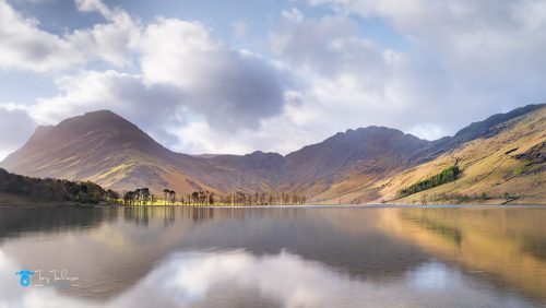
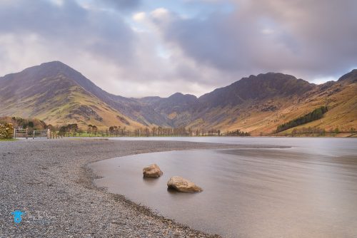
April photography got off to a slow start, my first jaunt out was to Buttermere on a cold but clear spring morning for some Lake District sunrise photography.
It was a bit of a punt as the weather gods were not lining up for anything special, still you need to be in it to win it, as they say.
Buttermere
This being one of the best photography locations in the Lake District, upon arrival, I was feeling quite confident that the weather conditions would develop and allow me to get some decent photographs.
Despite being the lone photographer here, I just stood and soaked up the atmosphere, a very slight breeze, which was swirling around, but leaving flat calm water in patches, clouds developing and the sun slowly lifting itself from the horizon.
Time to get busy with the camera as the light began to develop, but being very conscious of the ever-increasing dark clouds being blown across the lake from the southwest, Lake District photography at its best.
A Spring Morning
A short walk further along the lakes shore created some alternative compositions which were eagerly snapped up.
A Couple of Rocks
It was soon time to head home; the thought of a wholesome cooked breakfast was calling me home.
Catbells
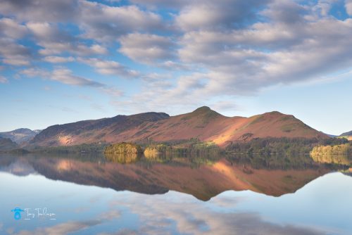
My next adventure was off to Derwentwater with the sole aim of capturing some special photographs of Catbells, in what I was going to be calm and pleasant conditions, and is one of the best photography locations in the Lake District
I was very conscious of the ever earlier alarm call in the mornings to get out intime for sunrise, we are heading for that silly season form late May to July.
I arrived well before sunrise with the conditions not looking too good, but it was early.
The light was poor, but there was very little wind, and a superb lake surface which was reflecting the fells on the far side of the lake.
I was set up and waiting for the conditions, during which I had a good conversation with a couple of fellow photographers, one from the South of the country, and one from the North East .
Here is me complaining about having to get up at daft o’clock, but these two have travelled considerable distances to photograph the Lakes.
The light arrived along with a very nice umbrella of clouds, these creating very nice, dappled light across the fells opposite.
A Spring Morning
I made the decision not to move, stay put in the hope that the conditions would come to me, and boy was it the correct decision.
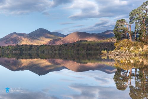
Friars Cragg to Causey Pike
Here I was, in the same position and my fellow photographer was returning from his walk along the lake’s shores, he must have thought that I was daft.
Having captured some quaint wide-angle images, it was time to attach the longer lens to start picking out more intimate shots
Causey Pike
After nearly 3 hours, it was time to pack-up head back to the car and look forward to editing the images that I had captured.
Hardknott Fell
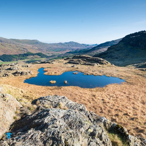
Late last year I headed to Hardknott Fell for a sunrise shoot, only to be thwarted by a road closure which prevented me driving to the fell.
My plan for Hardknott had not left me, so as we were experiencing some unusual fine spring weather with late sunsets of 8.30 pm, I decided to drive down to Hardknott Fell to have a mooch about.
Has I was driving south along the main Workington to Barrow road (A595) I realised how much traffic is created at end of the day shift at Sellafield, the road north was gridlocked all the way, strange how you except these conditions when you are part of it for years and years.
I was soon at the bottom of Hardknott Pass, an intimidating view when looking up as the road meanders up the side of the fell.
Thankfully the roads were very quiet, so it was time to select a low gear and face the extreme steepness of the pass.
Hardknott Pass
Once at the top it was time to find a parking place which did not contain a campervan, how these are so popular now.
I was soon stretching my calves as the path was straight up from the road level, I was walking into the unknown, but surly there would be ample photo opportunities once on the top of the fell?
There were views along Wrynose Bottom to the east, but the very harsh light was not complimenting the scene.
I then came across a small tarn which, after quite a while scouting about made my first image of the evening
A Rock and Tarn
I was soon off on my travels around the summit of the fell, Scaw Fell and Great Gable on view to the North, but again the harsh light made a photograph pointless.
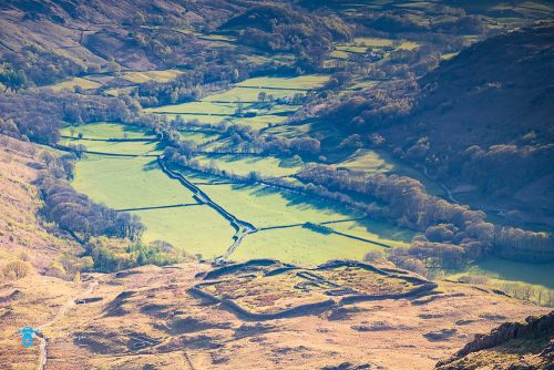
Next, over to the western side of the fell summit, it was here that I found the Roman Fort ruins in the bottom of the scene, these being contrasted against the extremely green Eskdale Valley floor.
The Roman Fort & Eskdale Valley
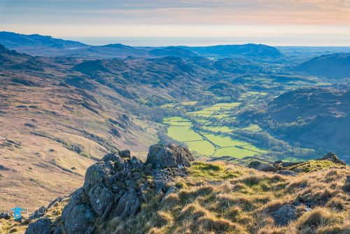
I also noticed that Devoke Water was in view sneaking around the corner of Harter Fell, in the far distance, so I set up a composition in landscape orientation including the Roman Fort in the bottom of the scene, but including the very small Devoke Water in the top lefthand of the image
A rocky outcrop on Hardnott Fell, the Eskdale Valley, and Devoke Water
The plan was to stay here until sunset in the hope of the sky becoming pink and orange, this was still over an hour away, so I set off on another trek looking to use the many strange and unique shaped rocks as foreground interest.
Unfortunately, the very harsh and extreme dynamic range (very dark, harsh shadow against brightly light areas) made this very difficult to capture, I took some over and under exposure images to blend together in post processing, but when on the computer, I was not happy with the results.
Great Gable from Hardknott Fell
It was now that I realised my waiting was in vain, the sun dropped behind the fells which resulted in everything being silhouetted against the sky, I was wanting to use some of the wester-facing fells as interest, but this was not possible.
Time to head home for a well-deserved hot meal.
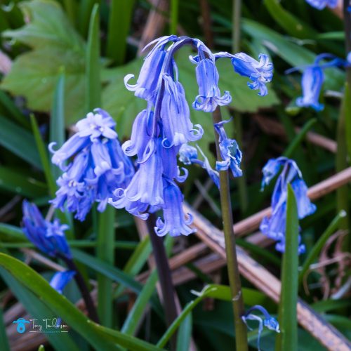
Grasmere
As it was Blue-Bell season, I wanted to visit a different location for the Bluebells to those that I had in the past, so it was time to head to Grasmere.
My research suggested that there are Bluebells within the woods along the banks of the River Rothay, and they are also on the side of Loughrigg Fell.
As me arrival time was 5.15 am for a 5.45 am sunrise, there were plenty of free car parking availability.
I was soon walking along the path on the banks of the River Rothay, Bluebells were visible, but these were not in full bloom, and were patchy, the sun had not risen at this time, so I decided to continue walking in the hope of finding a more interesting area of bluebells.
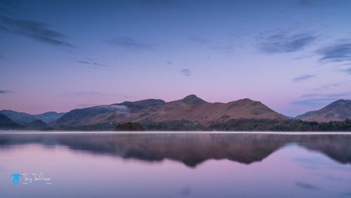
On the shore of Grasmere, having not seen any worthwhile Bluebell scene, I was conscious not to let the gate slam shut as there were two tents pitched right next to it, quietly, quietly it was.
The lake surface was very calm which was creating nice reflections of the surrounding fells and buildings, I stopped a couple of times to frame up a shot, but I was not happy with these, so I carried on around the lake towards Grasmere village.
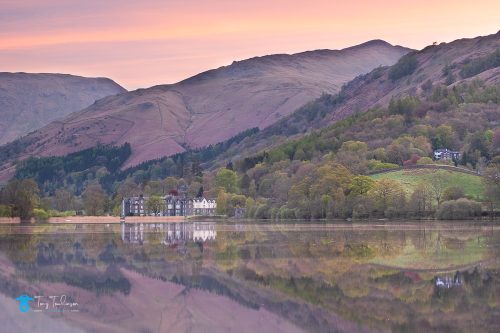
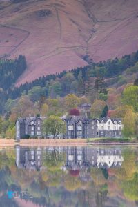
Quite by accident I stumbled over a little headland which provided a very good viewpoint of the Daffodil Hotel, time to set up and get the shot.
The first photograph of the morning, and what a good one it was.
Mere SunriseHotel Reflections
From here I moved left and right capturing slightly different images of the hotel.
Has I retraced my tracks towards Loughrigg Fell; I kept looking abut for other images of the surrounding scenes.
I then made the brave choice to hike up the fell to get on the Terrace path, this provides a great viewpoint over Grasmere towards the Pass of Dunmail, what I didn’t account for was the steepness of this route, boy was it bloody steep and hard work to get up it, shedding layers like a onion, I finally made it with my heart rate sky-high and me boiling hot.
After a cooling down, which took a while, and getting my heart rate back to normal, it was time to get cracking.
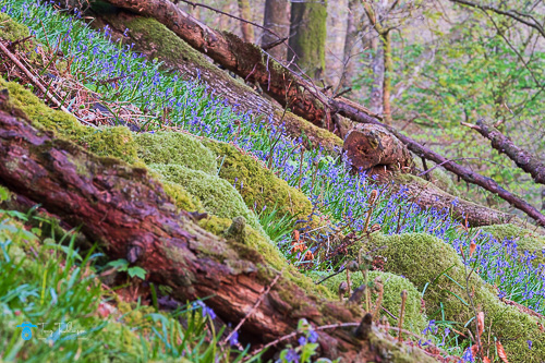
I found some Bluebells in a wood on the edge of the path which I had just hiked up, there were shadows and speckled light on these, so I tried to make a image from the scene. Not the best photo, but a start.
Logs & Bluebells
Whilst walking along the Terrace path, I came across some bluebells below the path, being careful not to treat on any of the flowers, I descended with the intention of getting some close-up photos of the flowers.
Bluebell Flower
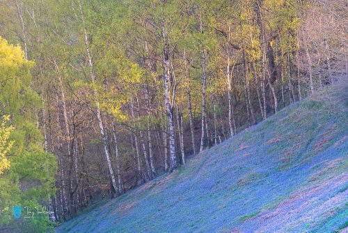
Back onto the path heading eastwards and has I crested a little ridge a sight to behold came in front of me, freshly leaved Silver Birch trees contrasting with a slope of solid Bluebells, this was the shot.
A little time to frame up the shop, and a slight wait for the light to develop, I got the shop.
Green & Blue
This was the best photo from the morning, one that made the visit worthwhile.
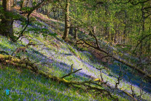
Has I descended into woods along the river, I found another group of Bluebells, the light was nice, but I found it difficult to create a decent image, the photo that I took was not that good, but it is attached below for reference.
Blue Highlights
A slow and leisurely walk back to the car completed a satisfactory 3 hours walking around the area.
Thank you for finding the time to read this blog, until the next one, stay safe.
As a Lake District Photographer, light is the essential, creative element in photography, acting as both the source of illumination and the primary tool for creating mood, depth, and texture.
Controlling light through natural or artificial sources determines the subject’s prominence, contrast, and overall atmosphere.
Understanding Light
To fully appreciate the importance of light in photography, even in the best photography locations in the Lake District, it is important to have a basic understanding of how light works.
Light is a form of energy that travels in waves, when light waves enter the human eye or a camera lens, where the brightness and colour are interpreted to create an image.
It is the perception of light waves that creates a picture.
Light is the most essential component of photography, but the fun doesn’t have to stop when the sun goes down, portable flash, speedlights (small portable flash units), or studio flash (larger, mains powered light units) can be used to create both soft and hard light under stringently controlled conditions.
Light defines the photograph through intensity, this can be either hard or soft light, the direction of the light upon the subject, and colour temperature of the light.
Soft and/or Hard Light.
Soft light can be categorised as being gentle and/or diffused light creating subtle shadows, often found on cloudy days or using soft boxes/diffusers in a studio environment these are ideal for flattering portraits.
Hard light is normally created by direct, intense light which creates harsh, defined shadows, this great for high-contrast, dramatic scenes.
Using the direction of light in your photographs:
Front Light, this normally Illuminates the subject evenly, minimizing shadows but can produce flat images.
Side Light this highlights texture and creates drama by illuminating one side of the subject.
Back Light is when the light source is positioned behind the subject, creating silhouettes or a glowing “rim light” effect that separates the subject from the background.
More than one direction of light can be used to illuminate the subject, this is normally used in studio photography where is easier to accurately set-up and control the different light sources to create the image that the photographer is looking to achieve.
Light Temperature
Light temperature can be measured in different ways; the Kelvin range uses a number value to a given temperature colour.
Colour temperature can also be changed using a slider/dial where the range can be aligned from the blue to yellow spectrum, as you move the slider/dial the temperature within the image changes according to the direction you are moving the slider/dial.
Examples of colour temperature are the golden hour, this would be rated a “warm” (yellow end of the colour spectrum) colour temperature, but an ice or snow scene would be rated as being “cold” (blue end of the colour spectrum) colour temperature.
A Lake District sunrise photograph would produce a “warm” colour temperature image, alternatively a Lake district winter photograph would produce a “cold” colour temperature image.
The following series of images are shot from the same location, but at different times to demonstrate the differing colour temperatures within the image.
A “Blue Hour” (pre-sunrise) photograph, shot at 4.54 am in the UK summer. This produces a predominantly “cold” or blue image.
Practical Tips for Managing Light
Time of Day, midday light is often harsh, while morning and afternoon offer warmer, softer light.
Modify the light by using reflectors to bounce light into shadows or diffusers to soften harsh sunlight.
Light Painting is where a moving light source is used during long exposures to illuminate specific areas of a scene, or create a light “trail”
The Role of Light in Photography
The way you use light in your photographs can greatly impact the overall look and feel of the image.
Light creates shadows, highlights, and contrast which can add depth and ambience to your photographs.
You should learn to experiment with the placing of light or move your subject around to see how the changing light impacts upon your subject; this can dramatically impact the look and feel of an image.
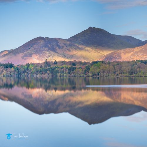
Sunrise produces a neutral colour temperature the image contains more “warmer” colours, but still has some “colder” tones within it. This image was captured at 5.14 am in the UK summer.
The Roll of Exposure in Photography
Another important aspect of using light in photography is exposure.
The exposure settings on your camera will dictate the amount of light that enters the camera and hits the camera sensor.
A proper exposure is essential for creating well-lit photographs that accurately capture the subject.
Techniques for using light in Photography
You can be as creative as you wish when experimenting with light but there are several techniques that are most effective when lighting your subject.
One technique is to use reflectors to bounce light onto your subject, this can help to fill in shadows and create an evenly dispersed lighting effect.
Another technique is to use a diffuser to soften harsh light, a diffuser can help to create a more natural-looking effect by spreading out the light and softening the intensity of shadows.
You can also experiment with different types of lighting to create different moods in your photographs.
Warm light can create a cosy and inviting atmosphere, while cool light can create a more clinical or sterile feel.
Another important technique to consider is the use of artificial lighting, studio lighting can help you to create a controlled lighting environment that allows you to highlight specific elements of your subject.
Tips for Using Light in Different Situations
Using light effectively in photography can be challenging in different situations, here are some tips for using light in different situations:
Outdoor photography:
When shooting outdoors, it’s important to pay attention to the direction and quality of the light. Early morning and late afternoon light can create a warm and inviting atmosphere, while midday light can be harsh and unflattering.
Try shooting in the shade or using a diffuser to soften harsh light.
By following these points, you are well on the way to produce images that will be suitable for landscape photography prints
Post sunrise produces a much warmer colour temperature the image contains mostly “warmer” colours. This image was captured at 5.59 am in the UK summer.
Indoor Photography:
Indoor photography shoots generally require artificial lighting; there are numerous options available to create your own studio so try experimenting with different types of lighting.
Reflectors, soft boxes, or light diffusers are a helpful tool when attempting to bounce light onto your subject.
As a family photographer in Cumbria, these actions are always assessed before and during a shoot to ensure the best possible results are obtained.
Portrait Photography:
When shooting portraits, the subject’s face is usually the focal point and the area that needs most attention.
Here, side lighting can create dramatic shadows, while front lighting can create a drab and unflattering look.
If the aim is to create a natural effect, a diffuser will soften any harsh light, any outdoor family photoshoot in the Lake District would embody these considerations.
Landscape Photography:
When shooting landscapes, the direction and quality of light will differ at different times of the day.
Early morning and late afternoon light can create a warm and soft atmosphere, while midday light can be overly severe, try using a polarising filter to reduce glare and create more vibrant colours.
You can use light to create depth and dimension where light can create long shadows and interesting highlights, this can add another dimension to photos and create additional depth.
Try experimenting with different lighting angles and intensities and observe how shadows and highlights behave as you move and adjust.
Conclusion
The importance of lighting in photography cannot be overstated, lighting is central to all photography and once you have a strong understanding of techniques and light quality, there is no stopping you from creating stunning images.
Thank you for finding the time to read this article, if you have any questions relating to “light” please get in touch.
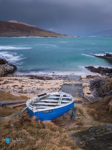
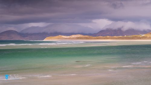
Today’s adventures began with a little lie-in, breakfast was at 7 am, then a visit to another local beach to our cottages.
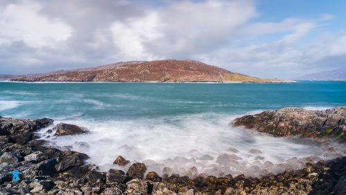
Geodh Mhartainn is a coastal cove or inlet located on the west coast of the Isle of Harris in the Outer Hebrides, which is known for its dramatic, rocky scenery and views over the Sound of Taransay.
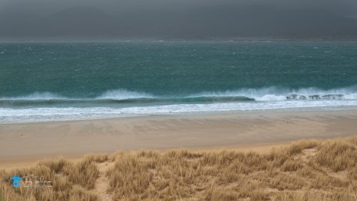
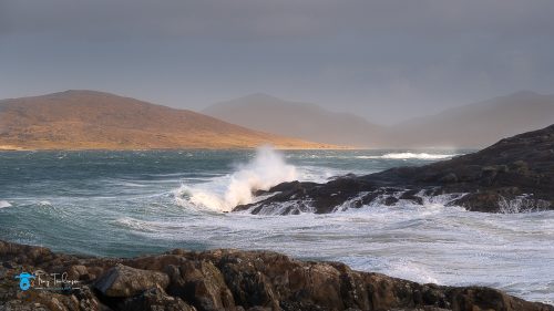
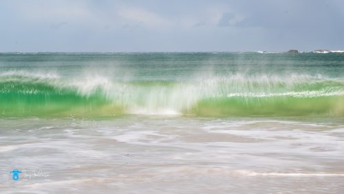
We arrived at the beach, to find that the wind had lost none of its ferociousness overnight, but it was creating the huge waves that were battering the shoreline.
I concentrated on trying to capture the waves as they crashed over the rocks and headland at this beach, I found it easier to set the camera on a fast shutter speed and fire blocks of shots off as the waves arrived.
This causes a lot of photos being rejected but gives you more chance of catching the ideal image from the block of images.
Geodh Mhartainn Seascape
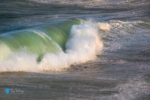
I then spent a little time trying to capture a wave as it broke further out from the shore, I was not that successful at this, but I did capture a couple of reasonable images
A powerful breaking wave
The problem of keeping the camera dry rose again, only this time the spray was coming form the breaking waves, this spray being salt water, so I sheltered the camera all the time as best I could and kept one drying cloth to had to wipe the camera at very regular intervals.
After a couple of hours on this beach, we loaded up the minibus to head for the Golden Road.
The Golden Road
The extreme bends of the Isle of Harris’s Golden Road tend to keep traffic to a minimum on this winding single track route through some of Harris’s rocky East Coast.
The road starts at Meabhag nam Bhaigh, before rejoining the main East Coast Road at Leacali.
It’s widely assumed it got its name because of the construction cost – If it cost that much then it must be made of gold! – but like much island folklore that is disputed.
Local historian, Bill Lawson says the name officially relates to the first sealed road in Harris, built in the years after World War Two, as a safety measure after many accidents as people waded across rivers to get home.
What it lacks in traffic it makes up for in scenery and wildlife. There is a wide range of birdlife to spot, and even seals basking on the rocks of the coast. Supposedly the views are better from the south (something else that splits opinions).
The environment along this road on the eastern side of the Island is very different for the west coast, extremely rocky, with a moon-like view.
The road is very undulating, one bend blends into another, and one change in elevation immediately meets another, not ideal conditions to travel if you have a dislike of undulating roads.
Soraya Photography Studio
We stopped off at the Soraya Photography Studio, a local woman who is an extraordinary wedding photographer and has on display some exceptional fine art prints for sale in her studio, these were for sale at reasonable prices.
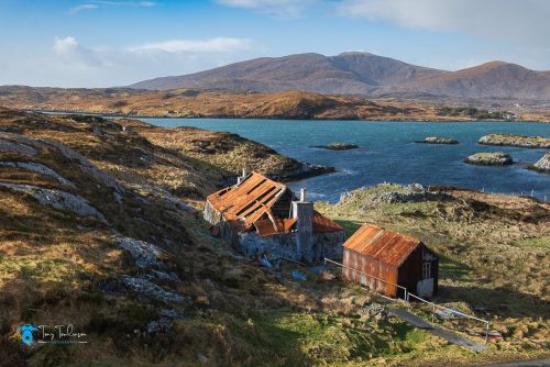
From here we travelled the short distance for the studio to photograph a derelict house on a little cove, the rusty corrugated roof making a nice comparison against the blue of the sea and sky and the green of the surrounding vegetation.
The ruined Old House on the Golden Road
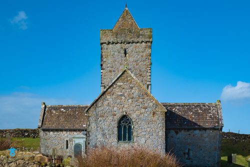
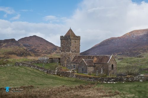
St Clements Church
End elevation of St Clements Church
St Clements Church is found on the southern end of the Island and a place that I have visited the last time that me and Carole visited the Islands.
The church was built for the Chiefs of the MacLeod’s of Harris, who lived in Dunvegan Castle in Skye, probably from about 1520, and is not considered the first church on the site although there is no clear evidence of an older Celtic church.
It was a Catholic church before falling into disuse shortly after its completion around 1560 as a consequence of the reformation, but the churchyard continued to be used as a MacLeod burial site.
The church’s decayed roof was renewed in 1784 by Captain Alexander MacLeod of Berneray but burned down shortly after and had to be rebuilt once again in 1787.
In the 19th century it was used as a cow byre before being restored by Catherine Herbert Countess of Dunmore in 1873, and in 1913, the tower was rebuilt after being damaged by a lightning strike six years earlier.
Today, the church is under the care of Historic Scotland.
In 1528, Alasdair Crotach MacLeod, the 8th Chief, prepared for himself a magnificent wall tomb on the south side of the choir – possibly the finest medieval wall tomb in Scotland, being crowned by an arch and ornated by carvings of biblical design.
The 9th Chief, Alasadair or Alexander’s son William, had his grave prepared in the south wall of the nave in 1539.
In the south transept, there is a third grave probably belonging to John MacLeod of Minginish, the 10th Chief.
There are five more grave slabs leaning against the wall of the north transept. The graveyard surrounding the church contains several MacLeod tombs.
Quite an history lesson for a church that is so remote.
St Clements Church
From the Church, we travelled around the southern end of the Isle of Harris, stopping off to have a look at the ferry terminal to Leverburgh for a look around the harbour.
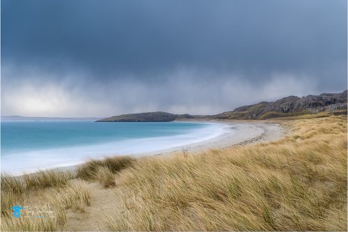
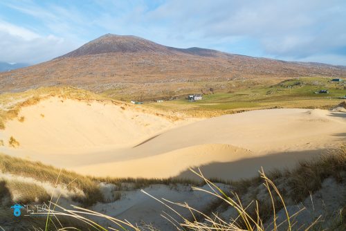
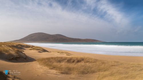
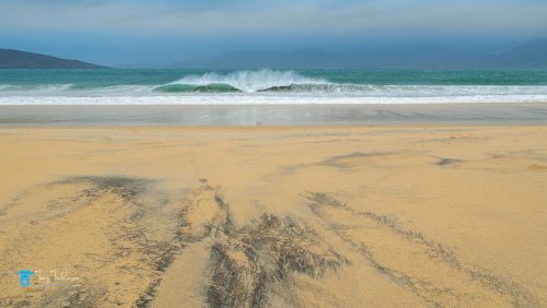
Sgarasta Mhor Beach
We ended up here as there were a group of photographers at the Northton Salt Marshes, so rather than wait around, Dean brought us to the Sgarasta Mhor Beach to photograph the beach from within the sand dunes.
You would not have thought that this was the same beach that we had visited earlier in the week, today, the sun was shining, but still bitterly cold, and the wind was still battering us.
I got into the sand dunes and began looking for a composition using the sand shapes and forms as foreground but being able to include the headland as the background.
The view across Sgarasta Mhor Beach
After a couple of hours here, were retraced our rout back to the Northton Salt Marshes.
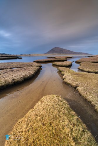
Northton Salt Marsh
From her we visited the Northton Salt Marshes, this is a well-known photography location which is beside the road, parking being the issue, it is a drive quite a way along the road to park, then retreat to the Salt Marsh on foot.
The photo opportunities are restricted to a couple of the small islands that are accessible for the shore as the water ways are deep and have a layer of thick claggy mud in the bottom of them, making them virtually impossible to navigate unless you have something to bridge the gaps between to small islands.
Northton Salt Flats
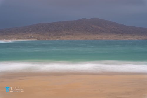
From the Salt Marshes, we headed for Luskentyre Beach, even though the clouds were gathering and the wind was picking up.
Luskentyre Beach
By the time we arrived at the car park at Luskentyre the weather gods had become angry, light drizzle in the air that was being driven by the strong winds.
We duly had a bit of a chat to see who wanted to shoot what, I wanted to try and get some atmospheric shots from the beach looking towards the Lewis mountains.
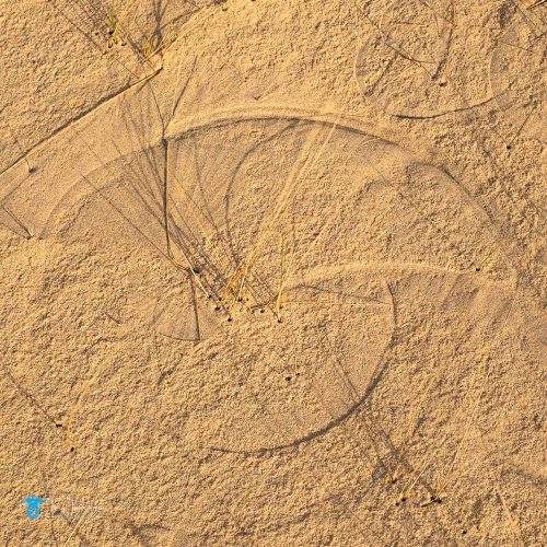
Others wanted to look for patterns I the sand at the northern end of the beach.
One I was exposed on the beach, the full force of the wind was battering me, again I was getting sandblasted, and it was getting everywhere.
I did manage to get a decent shot that I wanted of the mountains on Lewis and even sneaked a photo looking towards the Isle of Taransay, which meant turning into the head wind, which was carrying sand and rain.
Luskentyre Beach with the dark patterns in the sandThe Isle of Taransay from Luskentyre Beach
As the weather looked like it was in for the day the joint decision was to return to the cottage, get the equipment cleaned, and then for us to get showered, changed and have a leisurely late afternoon before our evening meal.
Day 6 of the Photography Workshop
Day six began with a early alarm and breakfast as we were again heading up the Isle of Lewis, this time to Bosta Beach on the Isle of Berneray on the Northwestern edge of the Isle of Lewis.
Another lengthy road journey to get us to Bosta Beach, but before that we crossed the bridge onto the Isle of Berneray, this was surprisingly short and there were two bridges side by side, apparently the old bridge was falling into disrepair, so the new one was built next to it.
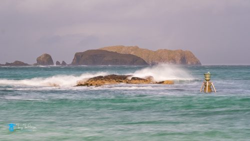
Bosta Beach.
Bosta Beach was approached by walking over a small headland, then getting absolutely battered by the onshore wind.
From here you could see the bay and the Sea Bell just offshore. The tide was covering the bottom of the bell which made it more photographic.
Offshore were the small islands of Flodaigh and Bearasaigh, these forming the backdrop when photographing the sea bell from this viewpoint.
Bosta Bell
I found this location very different and enjoyable to photograph, but once I got home this enjoyment was short lived as most of my photos that I took from the headland was not sharp, probably due to the bloody wind on the day.
I then went down onto the beach to try and photograph the incoming waves but using a slightly slower shutter speed to add some movement into the sea.
Breaking Waves at Bosta Beach
After a couple of enjoyable hours at Bosta Beach we retraced our route back towards the bridge onto the Island.
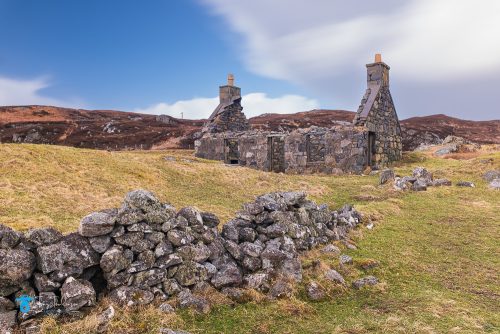
Berneray Old Bothy
We stopped just before the bridge to photograph a series of Bothy ruins next to the sea, (above) apparently there used to be a small ferry which crossed the estuary at this point before the bridges were built.
Kneep Harbour
Our next location was to be Kneep Harbour, a small historical island harbour on a small sea inlet.
We arrived to fishermen attending to their nest and carrying out some work on one of the fishing boats.
An old fishing boat perched high up on the slipway got my attention, I set out to take a photo of this boat but capturing the background so as to tell a story of the scene.
The old fishing boat at Kneep Harbour
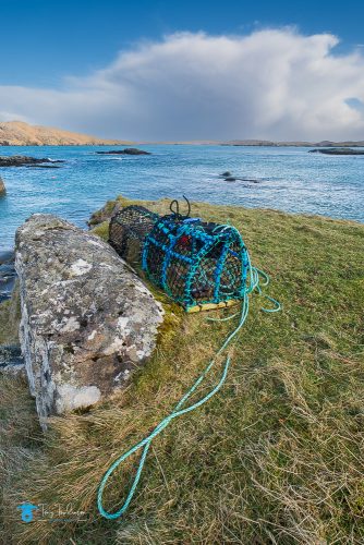
I then found a sole lobsterpot on some grass, the brightly coloured ropes on the pot contrasted against the grass on which it was sitting.
Kneep Harbour lobster pot
Kneep Beach
A short journey along the road got us to the lovely Kneep Beach, another gorgeous sandy beach with turquoise coloured water lapping up to it, and the island of Pabaigh Mor and Vacsay offshore.
It was here that I took some of my best photos of the whole trip, in sunny but cold conditions, and still be battered by the strong winds.
Kneep Beach
Dean then took us to the high interior of the Isle of Lewis to drive along the original track to Stornoway where we would find a selection of the old bothies.
The Sheilings
This area is named “the Sheilings”, a shieling is a little hut or cottage in the moors used in the summertime by the women and children who took the animals out, or by the people who worked the land, be it, Peet cutters, fishermen, and suchlike,
When photographing the wide selectin of buildings, I wanted to emphasise the remoteness and isolation of these buildings.
Some were actual ruins, but others looked as though they were complete which could be used.
More Sheilings, this time with a bright red door.
When we finished here, it was 4.45pm, so time for the long journey back to the cottages on the Isle of Harris, thus ending day 6 adventures.
Day 7 of the Photography Workshop
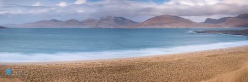
Day 7 began with another pre-breakfast session, this time at the nearby Sgarasta Beach at which we hoped to get a decent sunrise opportunity.
Dean again drove us the short distance to the off-load point.
Sgarasta Beach Sunrise
The plan was this morning we would end to the north end of the beach to revisit the little burn that we had been too a couple of days before, hoping to get some sunrise light this time.
Disappointingly, the sunrise was a none-event, but this did not stop me from getting some lovely atmospheric images from here.
An early morning photo across Sgarasta Mhor Beach
An enjoyable session followed by another hearty cooked breakfast provided by Sally.
Once breakfast was devoured, and we were all ready, it was off on our journeys for the last days photography.
This morning we were heading to a new location for me, a place called Huisinis, found in the northwest corner of Harris.
It was going to be over an hour’s travelling to get there, but we were soon stopped at the Seilebost Viewpoint as the conditions were sublime.
Seilebost Viewpoint
As we headed over the headland, the sight in front of us was exceptional, the early morning light was hitting the full width of waves heading towards the expanses of sand, we simply had to photography this scene,
We jumped out of the minibus, gabbed the camera to hand hold the camera for this series of photos that I took
Patterned waves at Seilebost
From here we headed to Huisinis
Huisinis Beach
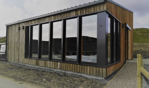
As we pulled up in the car park, which was right on the beach front, we were surprised to see a lovely large hut/shed at the end of the car park, I had to go and take a look around this, what could it be?
I was very surprised to see that the building was a café and toilet facility, an area overlooking the beach with floor to ceiling glass wall, vending machines, and open for anyone to use. The café area and the toilets were spotlessly clean, what a lovely facility, and all paid for by people donating towards the building of it.
The Huisinis Gateway Building, a cafe and toilet facility
There were a group of photographers on the beach in the place where Dean was taking us too, so he suggested that we head over the small headland where there are other photo opportunities of the sea and the small island of Scarp.
This is where me, George and Phillipe headed, there was a small ramp where fishing boats would be launched into the sea, a few small buildings, probably fishermen’s huts.
There was a fishing boat positioned on the slipway, so I captured a long exposure of this, and the long exposure flattening out the water’s surface.
PHOTO of fishing boat on slipway
I then saw a bothy on the Island of Scarp but positioned on a small headland, I took a series of shots of this.
Isle of Scarp, house on headland
I then positioned myself above a small rocky cove with the island of Scarp in the background. I experimented with a wide selection of shutter speeds to obtain different effects of the water.
Hushinish Peninsula Cove
From here me and George scrambled further around the bay to look for other compositions, what we found was a series of small cliffs and boulders that went into the sea, the waves were smashing into these which made for a nice composition, and there was a wrecked boat higher up on the cliffs, this had to be included in the photo!
Once me and George had taken all the shots we needed, we headed back to the others on the other side of the headland, all told, I got some interesting photos from here.
We retreated to the gateway building to tuck into our packed lunches, defiantly the best place we ate our lunches all week.
It was here that Dean offered us all a “free” afternoon, i.e. we could go to the place we wanted too (within reason) from where he would pick us up later in the afternoon.
The consensus was that Luskentyre was the place where we all would like to visit, as Scalpay (my selection) was not practicable due to the 50-minute walk to reach the location, then the same return time, this would severely reduce the time at the location.
Luskentyre Beach
Dean duly dropped us off at the car park at Luskentyre Beach from where he would collect us in two hours’ time.
Dave decided not to take up this offer and headed back to the cottage for the afternoon, meanwhile George and Phillipe again headed to the north of the beach, whilst I headed to the highest sand dune to investigate form there.
I was soon dragging myself along the dune ridgeline, then up to the top of the highest sand dune. This took some effort, trying to fight my way through the soft sand on the incline was far from easy, and I will be honest, I nearly threw the towel in.
Was the effort worth it, well once I got my breath back and surveyed the views, yes, defiantly, it was.
Looking down from the highest sand dune on Luskentyre
The height of the sand dune was surprising; it provided a very unique view of the surrounding area.
I also took a series of long exposure shots when looking out over the sea towards the mountains of Lewis.
Luskentyre Viewpoint from the highest sand dune
Once I was happy with this images that I captured, I decided to walk down to a lower sand dune to look at the compositions that this would provide, again experiencing very deep and loose sand whilst getting to this location.
I found some interesting patterns in the sand whilst walking this route, at first, I could not understand how they had been created, but then I realised that they were formed by the wind blowing the tall strands of grass around in the sand.
Patterns in the sand caused by the wind blowing the grasses.
Once in position on the lowered level of sand dunes, I shot through the Maran grass to create a very close foreground.
From upon High, waves crashing onto the beach
Checking the time, I was surprised to see that Dean would be returning in 30 minutes to collect us, so I began the long trek back to the carpark.
This curtailed the photography for the last full days photography of the workshop.
We headed back to the cottages for the final time, where we would cleanup, and pack our belongings for the following days departure.
When our evening meal was finished, we chatted on how we thought the week had gone, and what we had liked, and was there anything we were not happy with.
It was here that Phillipe explained that he was being collected by taxi at 6am the following morning to catch his flight from Stornoway to Glasgow, and from there to Belgium.
Dave was catching the ferry from Leverburgh to Berneray to continue his photography on the Outer Hebrides for another three days.
Meanwhile George was travelling with Dean to get back to Inverness from where he would be travelling to Northumbria for another photography workshop, before heading home to Australia at Easter, and Sally would be following Dean in her own vehicle.
This meant that four of us were catching the same ferry from Tarbert to Uig in the morning.
Chatting to Dave about the nightmare of travelling through Glasgow, he suggested that I return via Sterling, this would mean me missing the roadworks, with not allot of time added to my overall travel time.
Day 8: Homeward Bound
The day started with a hearty cooked breakfast, then the vehicles were loaded up and the rooms cleaned.
Dave was the second to leave (Phillipe had left at 6am) so we said our farewells as Dean drove him down to catch his ferry to Berneray.
Once the cottages were prepped and ready, we left them to head for the ferry.
The ferry crossing was through reasonable seas, not too much motion on the ferry. As we approached Uig the car deck was opened so I said my farewells to Dean, Sally and George.
My travel plans were to get to the Green Welly Shop as quickly as possible, which I did, only to find that the restaurant was closed.
My fault, I had not realised that it was 5.40pm in the afternoon. So, I grabbed a coffee and a couple of snacks to keep me going.
As I drove towards Crainlarig, I needs to make a choice, do I stick with the Loch Lomond route, or head to Sterling as Dave had suggested.
The levels of traffic on the road from the Kyle of Lochalsh had been sparse, and I had made good progress all the way to here, so I decided to stick to the Loch Lomond route.
Once I reached the Glasgow roadworks, the traffic was still light and I got through them with very little delay, thank heavens.
Once past Glasgow it was a straight 2.5 hour run to home, this ending the 8-hour return journey.
My reflection of the trip
Once home, unpacked, and sorted, it was time to reflect on the weeks adventure.
Had the weeks photography been worth it, of course, I was more than happy with the photographs that I took, sure, some had been disappointing, spoiled by not being sharp due to the extraordinary high winds, but that is a learning experience for me.
Did I get value from the weeks workshop, defiantly, whilst not being the cheapest photography course available, it was totally self-contained, once I reached the cottage on the Isle of Harris, my car never moved, nor did I need to buy a meal or drink (with the exception of using a local café on the island)
My final thoughts on the weeks workshop are that Dean was excellent in leading us around the Isle of Harris and Lewis, he was able to change locations to suit the weather conditions and displayed a wealth of knowledge on the numerous locations we visited and passed by.
I would not hesitate to recommend one of Dean Allan photography workshops.
Thank you for finding the time to read this second article from my week’s photography exploits on the Isle of Harris and Lewis, I hope you found it interesting


 Berneray Old Bothy